


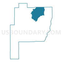
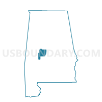
Severe, Perry County, Alabama
About
Outline

Summary
| Unique Area Identifier | 522769 |
| Name | Severe |
| County | Perry County |
| State | Alabama |
| Area (square miles) | 59.95 |
| Land Area (square miles) | 59.37 |
| Water Area (square miles) | 0.59 |
| % of Land Area | 99.02 |
| % of Water Area | 0.98 |
| Latitude of the Internal Point | 32.78059420 |
| Longtitude of the Internal Point | -87.17752340 |
Maps

Graphs
Select a template below for downloading or customizing gragh for Severe, Perry County, Alabama


Neighbors
Neighoring Voting District (by Name) Neighboring Voting District on the Map
- Heiberger Grocery-Armory, Perry County, AL
- National Guard Armory, Perry County, AL
- Pinetucky, Perry County, AL
- Radforville, Perry County, AL
- Rock Building-5, Bibb County, AL
Top 10 Neighboring County Subdivision (by Population) Neighboring County Subdivision on the Map
- Centreville-Brent CCD, Bibb County, AL (12,937)
- Marion CCD, Perry County, AL (4,760)
- Sprott CCD, Perry County, AL (1,055)
- Heiberger CCD, Perry County, AL (797)
Top 10 Neighboring Unified School District (by Population) Neighboring Unified School District on the Map
Top 10 Neighboring State Legislative District Lower Chamber (by Population) Neighboring State Legislative District Lower Chamber on the Map
Top 10 Neighboring State Legislative District Upper Chamber (by Population) Neighboring State Legislative District Upper Chamber on the Map
Top 10 Neighboring 111th Congressional District (by Population) Neighboring 111th Congressional District on the Map
Top 10 Neighboring Census Tract (by Population) Neighboring Census Tract on the Map
- Census Tract 100.04, Bibb County, AL (8,767)
- Census Tract 6870, Perry County, AL (5,557)
- Census Tract 100.03, Bibb County, AL (5,391)
- Census Tract 6868, Perry County, AL (1,055)